
Monitoring
Reduce Risk, Time & Cost
Incredible Group’s commercial drones and CAA Part 102 Certified drone operators vastly reduce the risk
and time involved in inspections, compared to physical inspections. Whether you need regular maintenance,
inspections/surveys, an urgent or emergency response, we have you covered – Incredible Group is on call 24/7
Safe, accurate & cost effective: drone Aerial Inspections & Surveys NZ-wide.
We obtain all Permissions required, e.g. from local authorities & airfields.
- Buildings, Assets, Utilities & Infrastructure
- Thermal Imaging (Thermographic Imaging)
- CAA Part 102 UAV Certification
- Full Aviation & $10M Public Liability Insurance
- 11,900+ Safety Verified logged flights
Accident / Disaster Response
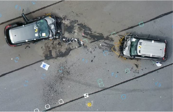
Drones are the latest tool to be deployed for accident / disaster response (and prevention). They are able to
quickly map every detail of an accident scene – preserving it for later analysis, while allowing the scene to be
cleaned much faster and regaining its functionality (for example allowing road traffic return to normal
operation). They can be deployed in minutes after arriving on scene and can start mapping the location even
while first responders are still on the scene – without interfering with their efforts. Typical accident scene can be
mapped in under 10-15 minutes. The details, precision and accuracy of the captured 3D data allow
investigators to analyse the scene offsite, back in the safety of their own office. Insurance companies are
provided with invaluable data. Manually describing scene is time consuming and very superficial – with many
details omitted or overlooked – only to be destroyed by the cleaning crew under the pressure to re-open the
location. The detailed 3D model allows investigators to “return” to the scene at any time in the future –
preserving all details like a time-capsule.
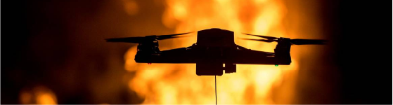
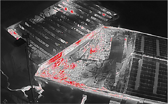
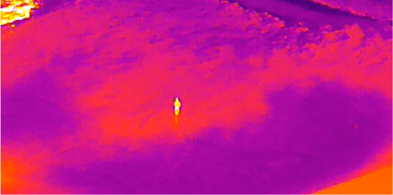
Infrared sensors allow drones to assist with fire-fighting. They can clearly show the areas of fire concentration –
even when hidden by thick smoke, or the building structure. This dramatically reduces the risk for firefighters
responding to the scene, while at the same time allowing them to better plan their actions and even assisting in
locating people in danger in a way not possible by manual in-person search. They can provide live feed to the
response centre – allowing for better coordination of the limited resources on the scene. And they are able to
do all of this from a safe distance – not interfering with the fire-fighting efforts. They can even safely guide other
full-size fire-fighting aircrafts responding to the scene.
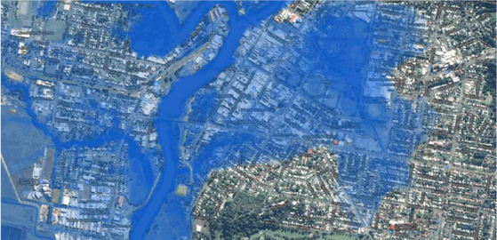
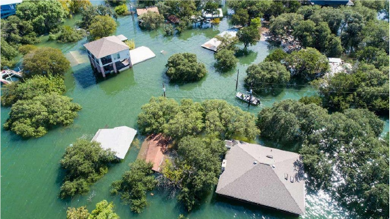
When responding to natural disasters such as flooding, earthquake and/or landslides – our drones can quickly
generate accurate 3D maps – allowing the responders to plan access and prioritise their response. This saves
lives not possible in any other way. The drones can access areas hard or impossible to reach really fast and
provide live high-resolution imagery. They can even deliver emergency supplies or medicine to these areas in a
rapid manner. Remote two-way communication is also possible between these hard-to-reach locations and the
rescuers. The drones can even provide temporary lighting, audio announcement equipment and wireless signal
when necessary. They can monitor the response and update the location maps in real-time, along with any
progress already made. They can keep track of the rescuers and their equipment.
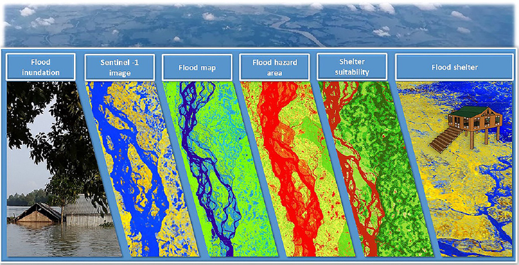
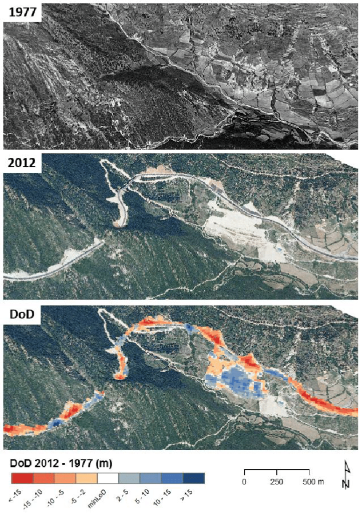
Furthermore our drones can be deployed for disaster prevention. We can generate precise 3D elevation maps
of at-risk areas – allowing for flooding risk mapping and advance response planing. We have generated
accurate 3D terrain maps used to calculate possible lahar flows on active volcanoes – and in hilly regions,
subject to frequent landslides triggered by heavy rains and/or earthquakes, we were able to highlight the most
dangerous areas – allowing for ground-strengthening engineering work to take place, reducing the landslide
risk dramatically. We have even installed live monitoring and real-time response drone systems on dangerous
locations (such as active volcanoes), allowing to alert local residents and the rescue / response teams 24/7.
The drones can respond to accidents that would put rescue personnel at great risk – such as nuclear accidents, gas leaks, fires at places storing dangerous chemicals, etc… We can outfit our drones with multitude of sensors – able to detect leaks of radiation, gas, or other dangerous chemicals. Drones can be easily replaced, unlike the rescue / response personnel. Any, even the smallest reduction of risks to the responders is priceless.
Search & Rescue
In search and rescue operations, teams race against the clock. Vision Aerial drones take less than two minutes
to deploy, whereas helicopters or planes take much longer. Drones also scan wide areas with cameras and
sensors more quickly than traditional grid methods. Once the subject is found, GPS coordinates provide SAR
teams with a precise location.
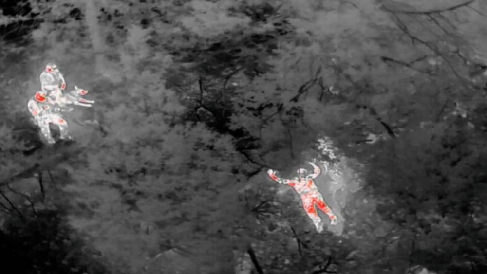
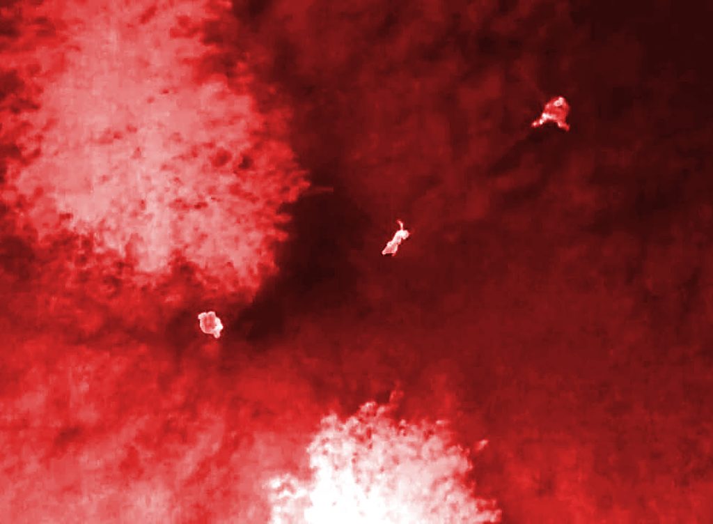
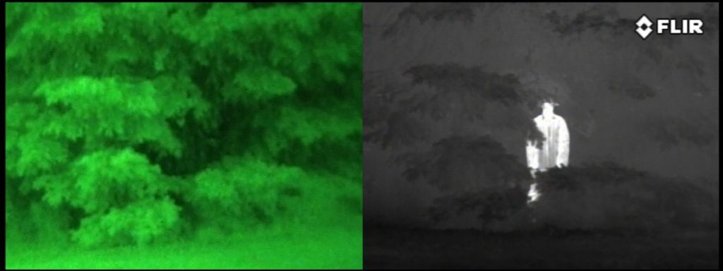
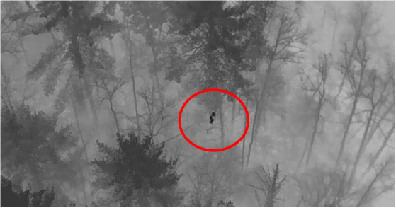
A drone outfitted with a thermal and infrared camera provides rescuers with information that is invisible to the
naked eye. For example, search teams on the ground can use a live-stream of thermal images to look for
human shapes. Once found, they zoom in with a high-resolution camera to assess the condition of the missing
person. That way they will know what kind of first aid might be needed. Finally, rescuers use precise GPS
coordinates to guide them to the subject.
While helicopters and airplanes can cost several thousand dollars per mission, a drone is a fraction of the cost
when amortized over its lifetime. Plus, rescuers can stay safely on the ground at the staging area and benefit
from live imagery provided by the drone.
Search and rescue missions often take place in remote locations with dense brush, cliffs, hills, ravines, or other
difficult terrains. Drones can fly high over areas that would be difficult to cross on foot. With an autonomous
range in excess of 15 km, our drones can quickly cover more ground.
Drones significantly lower the expenses associated with traditional methods. They eliminate the need for costly manned aircraft, reduce labor costs, and minimise the time and resources required for setup and operation. This enables more frequent, efficient aerial surveillance and better resource allocation for emergency response and critical situations. Drones offer rapid deployment and faster data collection. They can quickly cover large areas, providing real-time information and imagery, which is crucial in time-sensitive situations such as search and rescue operations.
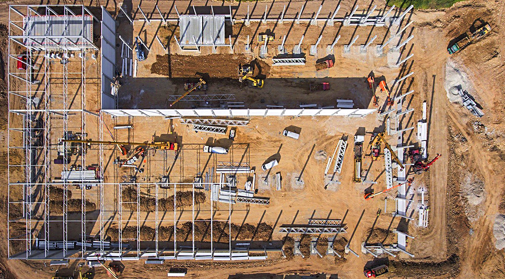
Construction Monitoring
Drones are making it easier than ever to automate progress tracking and remotely monitor construction sites.
Drone progress reports help ensure construction is finished on time and within budget. This post provides a
deep dive into construction progress monitoring and how drones are making it easier to stay informed about
what’s happening on site even if you’re hundreds of miles away.
Construction progress monitoring is the recurrent collection of information throughout a project’s lifecycle to
ensure construction is progressing as planned. Progress monitoring not only helps detect when a project has
fallen behind but also prevents delays before they happen. Project managers who collect progress reports
consistently are alerted to issues as they arise and can implement solutions early before the issue slows down
construction. Progress can be assessed on a daily, weekly, monthly, or quarterly basis depending on how often
updates are desired and the pace of the construction. With each assessment, the observations are compiled
into a progress report. These reports are valuable tools for project documentation, decision-making, and
communication with stakeholders.
Rather than a limited “boots-on-the-ground” perspective or trying to piece together bits of information relayed
from multiple departments/teams, a drone flight offers a singular, trustworthy, and consistent perspective.
Flying a drone over a construction site provides a fully inclusive aerial view of the site and the progress being
made. The result is an obvious improvement over traditional methods of progress monitoring.
Using a drone speeds up the process of surveying a construction site, and also cuts down on labor costs.
Additionally, drone software saves time afterward when compiling the progress report. All of the drone data can
be processed and organized into an easy-to-read report using drone software. This eliminates the hours it
would normally take to consolidate and organize all the information gathered manually. Managers can get
updates in real-time, reducing the lag time between when a change happens on site and when they actually
find out about it.
Areas that are dangerous to difficult to traverse on foot pose little problem to a drone. Eliminate safety risks to
workers by sending a drone to inspect those important assets and construction zones instead. New drone
images can be taken monthly, weekly, or daily depending on the speed of the project. Drones can provide
uniformity of perspective, location, and altitude with each inspection, making it easier to compare progress
over time. Providing consistent viewpoints in each progress report improves productivity and cuts down on
costs.
Keep members of various teams informed. Drone imagery can be shared with project managers, stakeholders,
and investors who’re interested in keeping tabs on the project. Implementing drones in your construction
workflow can completely change your companies’ operations throughout the entire bidding, planning, and
building process.
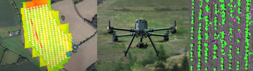
Agriculture Monitoring
The use of drones in almost every sector of the economy is growing fast, but drone usage in the agricultural
industry is booming. According to some reports, the agricultural drone market is expected to grow from a $1.2
billion(USD) industry in 2019 to $4.8 billion in 2024. Drone use will become more ubiquitous on large and small
scale farms in a few short years. The information gathered by drones on farms is often used to better inform
agronomic decisions and is part of a system generally referred to as ‘precision agriculture’.
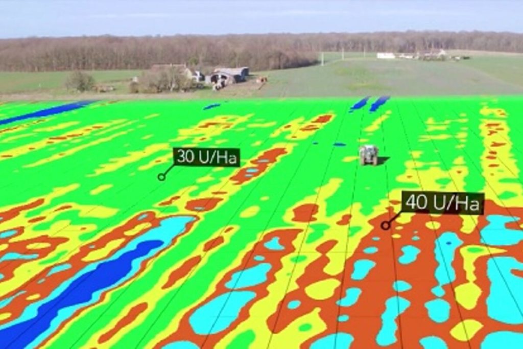
In many areas, drone use has become an essential part of large scale precision farming operations already. The
data collected from drones recording fields help farmers plan their planting and treatments to achieve the best
possible yields. Using precision farming systems can increase yields by as much as 5%, which is a sizeable
increase in an industry with typically slim profit margins.
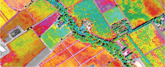
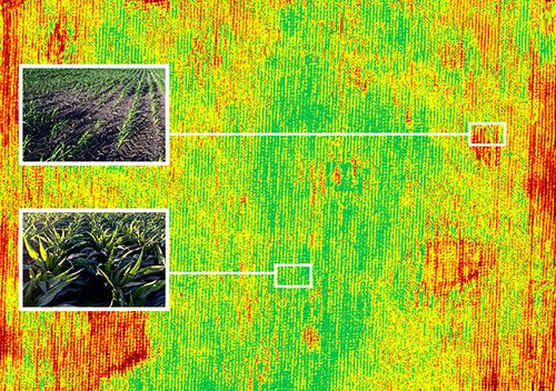
One of the uses for drone imagery that has already been rolled out with great success is for monitoring plant
health. Drones equipped with special imaging equipment called Normalized Difference Vegetation Index (NDVI)
use detailed colour information to indicate plant health. This allows farmers to monitor crops as they grow so
any problems can be dealt with fast enough to save the plants. This image illustrates simply how NDVI works.
Drones using ‘regular’ cameras are also used to monitor crop health. Many farmers already use satellite
imagery to monitor crop growth, density, and colouration, but accessing satellite data is costly and not as
effective in many cases as closer drone imaging. Because drones fly close to fields, cloud cover and poor light
conditions matter less than when using satellite imaging. Satellite imaging may offer to the meter accuracy, but
drone imaging is capable of producing accurate image location to the millimetre. This means that after planting,
areas with stand gaps can be spotted and replanted as needed, and disease or pest problems can be detected
and treated for right away.
Another drone technology in development also involves machine learning. Improving Artificial Intelligence (AI) in
drones is important to be able to make them more useful to smaller farmers. Current drone technologies are
more effective in monitoring well known crops like corn which are planted in large monocultural field patterns.
Drone monitoring programs, as they stand, have a hard time recognizing areas with increased crop diversity,
less well known produce, and grains which look similar throughout their growth stages and so are less effective
in monitoring crop growth and health. More work is needed to be able to train AI systems to recognize them.
Security
Drone surveillance provides real-time insight into security and emergency situations for better control, accurate
intelligence gathering, comprehensive situational awareness, and more informed decision making. Drone
surveillance is the use of unmanned aerial vehicles (UAVs) to capture still images and video from a distance or
at a high altitude to gather information about specific targets, which may be individuals, groups, or the
environment. Drones’ small size, ability to fly, and withstand harsh environments mean they can often survey
objects that may be out of reach and can get a first-person view that photographers don’t usually get.
Nowadays, security drones equipped with live video cameras, infrared cameras, thermal sensors, and LiDAR
are used in large numbers by law enforcement.
Emergencies require immediate action because every minute can be a difference between life and death. With
security drones, the process is much more effective. A drone for surveillance can perform perimeter patrols 30
times faster than a manned patrol, so it provides feedback in a few minutes. Surveillance UAVs can fly from a
high altitude that allows a wide aerial viewpoint without blind spots. With high resolution cameras, drones can
detect anomalies or events even in low light conditions and from hundreds of meters away.
By using remotely controlled drones, you can help reduce the risk to security staff, as pilots will be a safe
distance away. In the event of a suspect apprehension or disaster outbreak, it is best to send a drone to see
the situation first and investigate potential risks before humans get inside.
Based on your needs, Incredible offers the most trustworthy and suitable security and surveillance drones that
can carry various payloads and have different endurance. Whether you are faced with large surveillance areas,
difficult or steep terrain, huge altitude differences, adverse weather conditions, or no flat surface suitable for
take-off and landing, Incredible security drones can overcome all of these challenges. Please contact us with
any specific requirements you may have and we will find the most appropriate solution…